LAGOS-NE
Research Platform
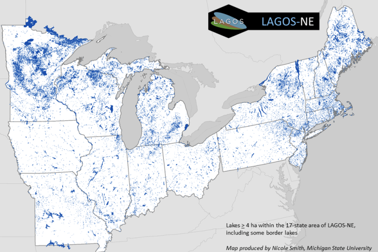
The LAGOS-NE Research Platform includes 17 lake-rich northeastern and midwestern states and 5 tribes in the United States (US) (Figure 1). LAGOS-NE includes 3 core data modules (LOCUS, GEO, LIMNO) that are described below, an R package for easily accessing the core modules, GIS datafiles for all lakes and watersheds within the geographic extent, and the ArcGIS code to create many of the metrics in the LOCUS and GEO modules. A data paper and a data methods paper were both published that introduced and described the approach for LAGOS-NE (Soranno et al. 2015, 2017).

Figure 1. The LAGOS-NE study extent of 17 lake-rich US states and all 51,101 lakes ≥ 4 ha in the study area.
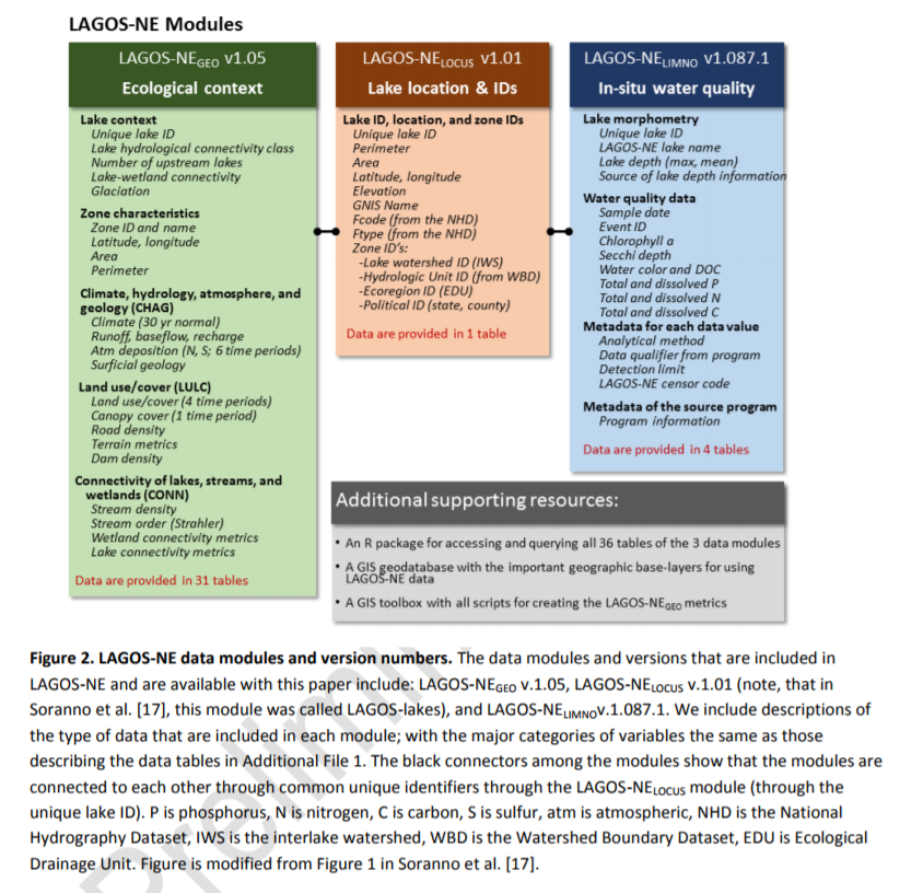
LAGOS-NE Core Modules

From Soranno et al. 2017. GigaScience.
LAGO-US GEO
Data Repository | User Guide | Data Paper
Provides land use/land cover, climate, hydrology, atmospheric, geological, and freshwater connectivity data for all 51,101 lakes at various spatial scales (local watersheds, regional watersheds, ecoregions, and political boundaries) and in some cases at multiple timesteps. Information on previous glaciation of lakes is also available.
- LAGOS_GIS_Toolbox for calculating GEO and LOCUS metrics.
LAGOS-US LOCUS
Data Respository | User Guide | Data Paper
Contains location data, lake names (for named lakes), and physical attributes for all 51,101 lakes ≥ 4 ha and their watersheds across the 17 northeastern and midwestern states. For a subset of lakes, we provided maximum and/or mean depth data when available (approximately 10,000 and 4,000 lakes, respectively).
- LAGOS-NE-GIS provides lake and watershed shapefiles for all 51,101 lakes. LAGOS-NE does not distinguish between lakes and reservoirs. We also provided a lake connectivity classification (e.g., headwater, isolated) for all lakes.
LAGOS-US LIMNO
Data Repository | User Guide | Data Paper
Provides quality-controlled, unit-standardized in situ water quality data for approximately 10,000 lakes across the 17 northeastern and midwestern states over the years 1965-2013. We compiled water quality data from 87 state, federal, citizen science, nonprofit, tribal, and university lake monitoring programs. Water quality variables include Secchi depth (water clarity), chlorophyll-a, total and dissolved phosphorus and nitrogen, water color, and dissolved organic carbon. All data are for surface/epilimnion (except water clarity) and data availability varies across water quality variables. We also provided sampling program information, sampling methods, and metadata associated with water quality observations.
LAGOS-NE R package for accessing LAGOS-NE data modules to facilitate access and use of LAGOS-NE data. This package contains functions for loading and querying data.
Full citations of data and code
- Soranno P., K. Cheruvelil. 2019. LAGOS-NE-LIMNO v1.087.3: A module for LAGOS-NE, a multi-scaled geospatial and temporal database of lake ecological context and water quality for thousands of U.S. Lakes: 1925-2013. Environmental Data Initiative. https://doi.org/10.6073/pasta/08c6f9311929f4874b01bcc64eb3b2d7.
- Soranno P., K. Cheruvelil. 2017. LAGOS-NE-LOCUS v1.01: A module for LAGOS-NE, a multi-scaled geospatial and temporal database of lake ecological context and water quality for thousands of U.S. Lakes: 1925-2013. Environmental Data Initiative. http://dx.doi.org/10.6073/pasta/940b25d022c695b440e1bdbc49fbb77b.
- Soranno P., K. Cheruvelil. 2017. LAGOS-NE-GEO v1.05: A module for LAGOS-NE, a multi-scaled geospatial and temporal database of lake ecological context and water quality for thousands of U.S. Lakes: 1925-2013. Environmental Data Initiative. http://dx.doi.org/10.6073/pasta/b88943d10c6c5c480d5230c8890b74a8.
- Stachelek, J., Oliver, S., Masrour, F. (2019). LAGOSNE: Interface to the Lake Multi-scaled Geospatial and Temporal Database. R package version 2.0.2. https://cran.r-project.org/web/packages/LAGOSNE/index.html
Photo Credit: Patricia A. Soranno.
