LAGOS-US
Research Platform
The LAGOS-US Research Platform includes the 479,950 lakes and reservoirs > 1 ha in the 48 conterminous US states. This study extent includes nationally recognized Tribal lakes and lands, as well as lakes and lands ceded as part of treaties and forcibly taken by the US government. The Research Platform includes both core and extension data modules (Figure 1).

Figure 1. Diagram of the LAGOS-US research platform, consisting of three core modules (GEO, LOCUS, LIMNO) and four extension modules (RESERVOIR, DEPTH, HUMAN, NETWORKS, LANDSAT). The expectation is that other researchers will build additional extension modules for future users of the LAGOS-US platform.
LAGOS-US Core Modules
LAGOS-US GEO
Data Repository & User Guide | Code
Contains geospatial and temporal ecological context variables for all lakes in LOCUS characterized at multiple spatial divisions (e.g., equidistant buffers around lakes, watersheds, ecoregions). Ecological context variables were derived from various public datasets and pertain to land use/land cover, climate, hydrology, freshwater connectivity, terrain, soils, land ownership and protection, atmospheric pollution, and other human activities such as roads and dams.
GEO Data Citation
- Smith, N.J., K.E. Webster, L.K. Rodriguez, K.S. Cheruvelil, and P.A. Soranno. 2022. LAGOS-US GEO v1.0: Data module of lake geospatial ecological context at multiple spatial and temporal scales in the conterminous U.S. ver 2. Environmental Data Initiative. https://doi.org/10.6073/pasta/53ae2afd051a6a082a2ab129e4281e13 (Accessed 2022-06-28).
LAGOS-US LOCUS
Data Repository & User Guide | Code | Data Paper
Contains locational (i.e., latitude, longitude, elevation), identifying (e.g., lake names, lake identifiers from non-LAGOS datasets), and physical (e.g., area, perimeter, shape) information of all lakes ≥ 1 ha and their watersheds in the conterminous U.S. Additionally, LOCUS provides information about freshwater connectivity (i.e., whether each lake is hydrologically isolated seasonally, 6-category classification based on the presence of upstream lakes and streams) and identifies all lakes that were previously glaciated. Geospatial files for lakes and watersheds as well as tables for linking across other LAGOS modules and broad-scale lake databases are available. LOCUS data can be linked across LAGOS data products using the unique lake identifier (lagoslakeid).
LOCUS Data Citation
- Smith, N.J., K.E. Webster, L.K. Rodriguez, K.S. Cheruvelil, and P.A. Soranno. 2021. LAGOS-US LOCUS v1.0: Data module of location, identifiers, and physical characteristics of lakes and their watersheds in the conterminous U.S. ver 1. Environmental Data Initiative. https://doi.org/10.6073/pasta/e5c2fb8d77467d3f03de4667ac2173ca (Accessed 2021-12-13).
Data Paper Citation
- Cheruvelil, K.S., Soranno, P.A., McCullough, I.M., Webster, K.E., Rodriguez, L.K. and Smith, N.J. 2021, LAGOS-US LOCUS v1.0: Data module of location, identifiers, and physical characteristics of lakes and their watersheds in the conterminous U.S. Limnol Oceanogr Letters 6: 270-292. https://doi-org.proxy1.cl.msu.edu/10.1002/lol2.10203
Bulletin Article Citation
- Soranno, P.A., K.E. Webster, N.J. Smith, J. Díaz Vázquez, K.S. Cheruvelil. 2020. What Is in a “Lake” Name? That Which We Call a Lake by Any Other Name. Limnology and Oceanography Bulletin 29: 1-7. https://doi.org/10.1002/lob.10355
LAGOS-US LIMNO
Contains in situ epilimnetic/surface water limnological physical, chemical, and biological measurements for a subset of LOCUS lakes through time from 1975 to 2021. Water quality data were obtained from the USGS Water Quality Portal, the US NSF National Ecological Observatory Network (NEON), and the US EPA National Lakes Assessment Program. Data were harmonized across all programs as well as integrated into the LAGOS-US research platform’s model to be easily used with all other LAGOS-US data products. In addition to common water quality variables such as water clarity, nutrients, chlorophyll-a, dissolved organic carbon, and color, LAGOS-US-LIMNO provides observations of water temperature, dissolved oxygen, pH, alkalinity, conductivity, numerous ions and contaminants, turbidity, E. coli, microcystin, and others. Detailed information on sampling (i.e., methods, dates), as well as laboratory methods and other important metadata are provided with the lake observations.
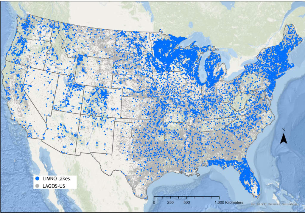
Locations of LAGOS-US research platform lakes that contain in situ data within the LIMNO module.
LIMNO Data Citation
- Shuvo, A.K., N.R. Lottig, K.E. Webster, A. Delany, K. Reinl, C. Gries, N.J. Smith, A.C. Poisson, I.M. McCullough, S.M. Collins, K.B. King, E. Phillips, K.S. Cheruvelil, and P.A. Soranno. 2023. LAGOS-US LIMNO: Data module of surface water chemistry from 1975-2021 for lakes in the conterminous U.S. ver 5. Environmental Data Initiative. https://doi.org/10.6073/pasta/2c58f5a50ab813919f99cc1f265f271c (Accessed 2023-09-26).
LAGOS-US Extension Modules
LAGOS-US RESERVOIR
Data repository & User Guide | Code | Data Paper
The RESERVOIR extension module provides a predicted classification of the subset of LAGOS-US lakes that are ≥ 4 ha (n = 137,465). Each lake is classified as either a natural lake or reservoir using a machine-learning algorithm and aerial imagery (Figure 6). Classification accuracy was approximately 80%, which was further improved upon by comparison to NHD codes and other methods.

Figure 6. LAGOS-US RESERVOIR v1 map and histograms depicting locations of 137,465 lakes ≥ 4 ha as NL (purple, n = 73,053), RSVR_A (orange, n = 61,042), or RSVR_B (green, n = 3370) in the conterminous U.S. states (black outlines). RSVR polygons were the first GIS layer to be plotted; therefore, some NL polygons may overlap or hide the true spatial extent of all RSVRs.
Data Citation
- Polus*, S.M., P.J. Hanly*, L.K. Rodriguez, Q. Wang, J. Díaz Vázquez, K.E. Webster, P. Tan, J. Zhou, L. Danila, P.A. Soranno, and K.S. Cheruvelil. 2022. LAGOS-US RESERVOIR: Data module classifying conterminous U.S. lakes 4 hectares and larger as natural lakes or reservoirs ver 2. Environmental Data Initiative. https://doi.org/10.6073/pasta/f9aa935329a95dfd69bf895015bc5161 (Accessed 2023-01-28).
* joint first-authors
Data Paper Citation
- Rodriguez, L.K., Polus, S.M., Matuszak, D.I., Domka, M.R., Hanly, P.J., Wang, Q., Soranno, P.A. and Cheruvelil, K.S. (2023), LAGOS-US RESERVOIR: A database classifying conterminous U.S. lakes 4 ha and larger as natural lakes or reservoir lakes. Limnol. Oceanogr. Lett. https://doi.org/10.1002/lol2.10299
LAGOS-US NETWORKS
Data Repository & User Guide | Code | Data Paper
The NETWORKS extension module used graph theory methods to provide additional, quantitative information about the surface water connectivity of LAGOS-US lakes. It consists of 898 lake networks (86,511 total lakes ≥ 1ha) and provides quantitative freshwater connectivity metrics for those networks and lakes (Figure 4).

The 898 unique lake networks (individual colors) in the conterminous US in LAGOS-US-NETWORKS.
Data citation
- King, K.B., Q. Wang, L.K. Rodriguez, M. Haite, L. Danila, P. Tan, J. Zhou, and K.S. Cheruvelil. 2021. LAGOS-US NETWORKS v1.0: Data module of surface water networks characterizing connections among lakes, streams, and rivers in the conterminous U.S ver 1. Environmental Data Initiative. https://doi.org/10.6073/pasta/98c9f11df55958065985c3e84a4fe995 (Accessed 2021-12-13).
Data Paper citation
- King, K.B.S., Wang, Q., Rodriguez, L.K. and Cheruvelil, K.S. (2021), Lake networks and connectivity metrics for the conterminous U.S. (LAGOS-US NETWORKS v1). Limnol Oceanogr Letters, 6: 293-307. https://doi-org.proxy1.cl.msu.edu/10.1002/lol2.10204
LAGOS-US DEPTH
Data Repository & User Guide | Bulletin Article | Analysis Paper
The DEPTH extension module is a manual compilation of mean and/or maximum depth for 17,675 lakes ≥ 1 ha from a wide range of sources (Figure 5).
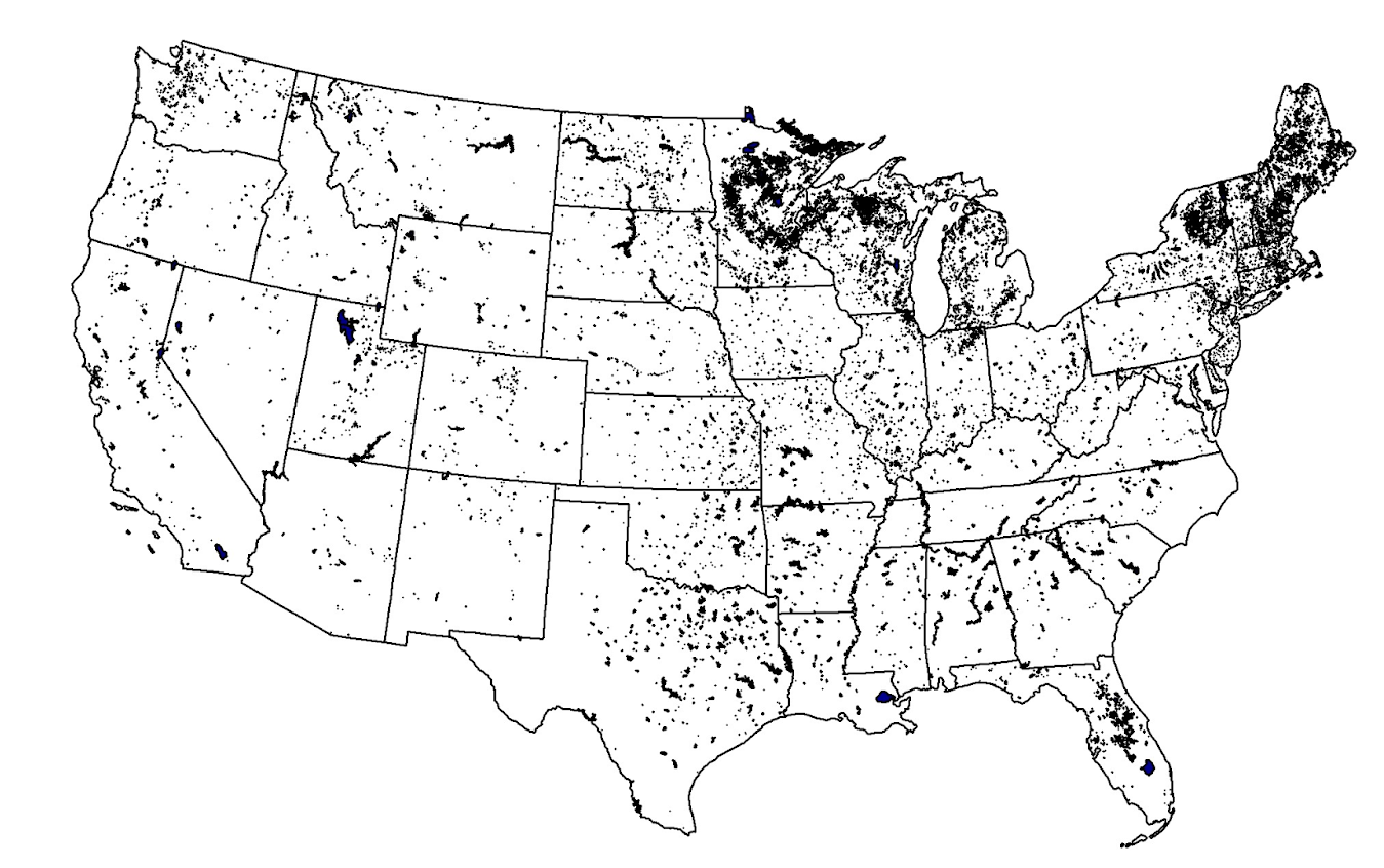
Lakes in the conterminous U.S. with depth data in LAGOS-US DEPTH.
Data Citation
- Stachelek, J., L.K. Rodriguez, J. Díaz Vázquez, A. Hawkins, E. Phillips, A. Shoffner, I.M. McCullough, K.B. King, J. Namovich, L.A. Egedy, M. Haite, P.J. Hanly, K.E. Webster, K.S. Cheruvelil, and P.A. Soranno. 2021. LAGOS-US DEPTH v1.0: Data module of observed maximum and mean lake depths for a subset of lakes in the conterminous U.S. ver 1. Environmental Data Initiative. https://doi.org/10.6073/pasta/64ddc4d04661d9aef4bd702dc5d8984f (Accessed 2021-12-13).
Bulletin Article Citation
- Webster, K.E., I.M. McCullough, and P.A. Soranno 2022. Deeper by the dozen: Diving into a database of 17,675 depths for U.S. lakes and reservoirs. Limnology and Oceanography Bulletin, 31: 1-5. https://doi.org/10.1002/lob.10482
Analysis Paper Citation
- Stachelek, J., Hanly, P., Soranno, P.A. 2022. Imperfect slope measurements drive overestimation in a geometric cone model of lake and reservoir depth. Inland Waters. https://doi.org/10.1080/20442041.2021.2006553
LAGOS-US LANDSAT
Data repository | Code | Data Paper
The LANDSAT extension module providesremotely sensed, ground-truthed water quality dataset for US lakes ≥4, spanning 37 years and covering >100,000 lakes. The data include six key water quality variables (chlorophyll-a, Secchi depth, turbidity, true color, DOC, and TSS) derived through machine learning and validated by over 700,000 in situ matchups from LAGOS-US LIMNO.

LAGOS-US HUMAN
The LAGOS-US HUMAN v1 data package is an extension module of the LAGOS-US research platform that includes data characterizing human population (population count, race, ethnicity, socioeconomic information), urbanization, and lake access of 479,950 lakes larger than or equal to 1 ha in the conterminous U.S.

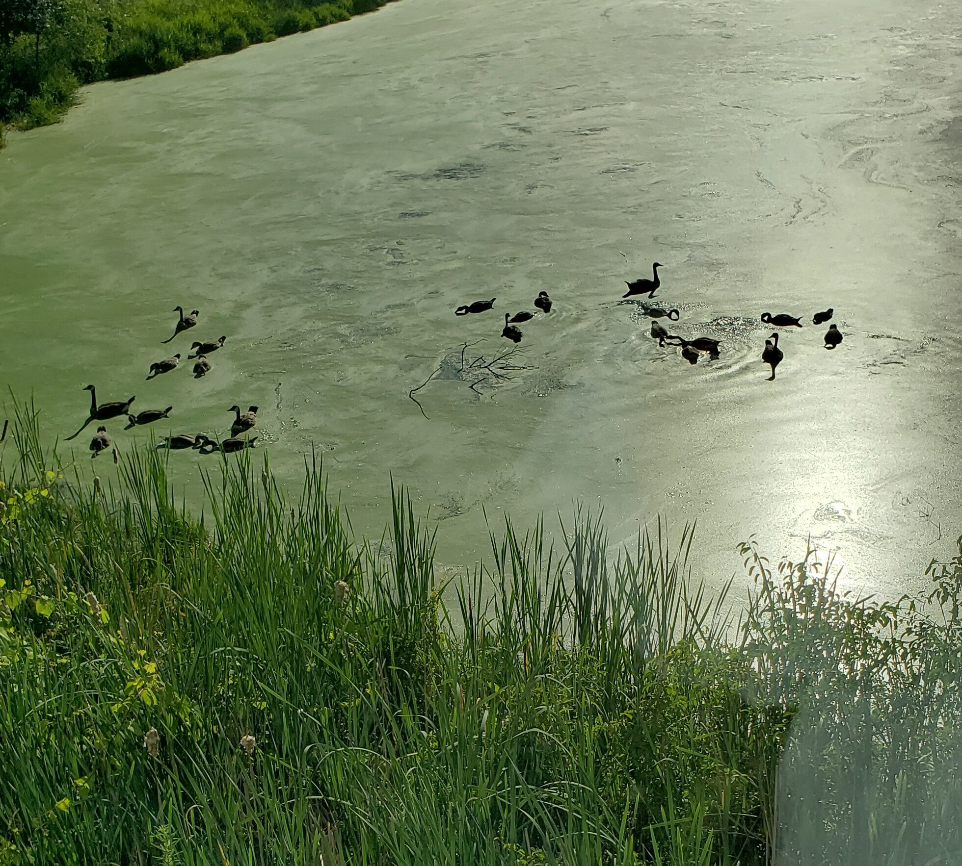
Photo Credit: Patricia A. Soranno.